


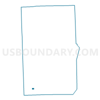
Voting District 0991432000002, Macomb County, Michigan
About
Outline

Summary
| Unique Area Identifier | 598031 |
| Name | Voting District 0991432000002 |
| County | Macomb County |
| State | Michigan |
| Area (square miles) | 0.20 |
| Land Area (square miles) | 0.20 |
| Water Area (square miles) | 0.00 |
| % of Land Area | 100.00 |
| % of Water Area | 0.00 |
| Latitude of the Internal Point | 42.48007030 |
| Longtitude of the Internal Point | -83.02171660 |
Maps

Graphs
Select a template below for downloading or customizing gragh for Voting District 0991432000002, Macomb County, Michigan


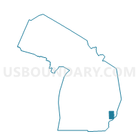
Neighbors
Neighoring Voting District (by Name) Neighboring Voting District on the Map
- Voting District 0991432000001, Macomb County, MI
- Voting District 0991432000003, Macomb County, MI
- Voting District 0991432000004, Macomb County, MI
- Voting District 0991432000005, Macomb County, MI
- Voting District 0998400000028, Macomb County, MI
- Voting District 0998400000047, Macomb County, MI
- Voting District 0998400000048, Macomb County, MI
Top 10 Neighboring County Subdivision (by Population) Neighboring County Subdivision on the Map
Top 10 Neighboring Place (by Population) Neighboring Place on the Map
Top 10 Neighboring Unified School District (by Population) Neighboring Unified School District on the Map
Top 10 Neighboring State Legislative District Lower Chamber (by Population) Neighboring State Legislative District Lower Chamber on the Map
Top 10 Neighboring State Legislative District Upper Chamber (by Population) Neighboring State Legislative District Upper Chamber on the Map
Top 10 Neighboring 111th Congressional District (by Population) Neighboring 111th Congressional District on the Map
Top 10 Neighboring Census Tract (by Population) Neighboring Census Tract on the Map
- Census Tract 2680, Macomb County, MI (5,653)
- Census Tract 2684, Macomb County, MI (3,724)
- Census Tract 2681, Macomb County, MI (2,604)
- Census Tract 2626, Macomb County, MI (2,412)